Gayle Harper

Photographer ~ Author ~ Traveler

  • Home
  • About Gayle
  • About the Book
  • Praise
  • News
  • Media Room
  • Blog
  • Contact
Follow Us on FacebookFollow Us on TwitterFollow Us on Google+

Subscribe to Blog via Email

Enter your email address to subscribe to this blog and receive notifications of new posts by email.

Join 187 other subscribers

Recent Posts

  • DELIGHT – The Circle of Healing Love
  • Hello? It’s Gayle Harper…wondering if anyone is still here?
  • The Hundred Acre Wood
  • The Circle of Life
  • First Day of Spring

Recent Comments

  • Deborah Rowell on Hello? It’s Gayle Harper…wondering if anyone is still here?
  • Gayle on DELIGHT – The Circle of Healing Love
  • Diana West on DELIGHT – The Circle of Healing Love
  • Gayle Harper on DELIGHT – The Circle of Healing Love
  • Gayle Harper on Hello? It’s Gayle Harper…wondering if anyone is still here?

Archives

Ongoing Effects of 2011 Flood

September 10, 2011 by Gayle Harper Leave a Comment

Nearly three months ago I shared with you the devastating effects of the great flood of 2011 on the people of Mississippi County, Missouri. I invited you to contact the U. S. Army Corps of Engineers and implore them to “do the right thing” and help these folks put their lives back together. Many of you did; many sent me copies of your emails and of responses from the Corps. Again, my heartfelt thanks for that! We were joined by voices of elected officials and empathetic people from all over the country and things looked hopeful.  Unfortunately, it hasn’t turned out as hoped and the people of Mississippi County are struggling. Here is the situation –

On May 2nd, the U. S. Army Corps of Engineers detonated 250 tons of explosives inside the Bird’s Point Levee at three separate locations. The act, which was part of a plan to save the city of Cairo, Illinois, and other downriver communities, allowed a torrent of Mississippi water to roar in at a rate of 550,000 cubic feet per second. As a result, nearly 100 homes, 130,000 acres of farm land and countless silos and barns were immediately destroyed. I toured the area by boat and plane in May and was overwhelmed by the extent of devastation. Click back to the posts in May and June to see some of those photos and stories.

Since then, there have been myriad studies, meetings and evaluations, but very little actual help. People whose homes and farms were destroyed are still without answers or assistance. They are still crammed into the homes of relatives or friends, unsure of any options for their future. These are resilient and independent people; many are the 6th generation of their family to farm this land. They are pragmatic about living near the River; they accept it will flood occasionally and some crops will be lost. They even accept that some homes may be flooded and the messy goo will need to be cleaned up. But, the force of the water released by these blasts is unprecedented. It tore apart the homes and barns and crushed the silos like paper cups. It gouged networks of ravines in former cornfields, leaving holes as deep as 60 feet in some. It washed away miles of roads and bridges. The African American community of Pinhook (in the post of May 29) is a ghost town. One couple is staying on their second floor; the rest of the homes lie around them in uninhabitable ruins.

Not only has financial assistance to those affected come only in dribbles, far below anyone’s estimate of the damage, but the Corps of Engineers has now made a decision which projects a bleak future for everyone. The Bird’s Point Levee, they have decided, will only be rebuilt to an “interim” level, which is 10.5 feet lower than when it was destroyed. Since the River has exceeded that level in 12 of the past 20 years, it seems only a question of when, not if that lower levee will be overtopped, inundating the area again.

After my own research, I do understand that these are incredibly complex decisions. The Corps must take into consideration the interests of many different entities. We all know that funding is tight and that nature has given the Corps plenty to do this year. Still, stopping the levee rebuilding more than ten feet below the previous level seems a short-sighted and dangerous act and no one, not even the Corps, seems to be saying that it can prevent disaster.

As I visited downriver communities after the flood, people there expressed their appreciation for the sacrifice required of Mississippi County. They did feel it made a difference. The release of all that water into Mississippi County, they said, relieved the pressure on their levees and helped minimize the damage. Does it not seem these folks have sacrificed enough? Is it not time to say thank you and help them pick up the pieces of their lives??

A documentary film was premiered yesterday in East Prairie, Missouri, telling the story of the devastation and the ongoing struggle of the people there. It has just now been made available online. Please take a moment to see it – just click this link www.disasteratbirdspoint.com   Click the “Watch the Video” button and then, if you are moved to do so, add your voice to those calling for the Corps of Engineers to help the people of Mississippi County, fix what they broke and fully restore the levee. You can easily help in whatever way you choose by using the buttons available on this site.

The events of our world pass quickly these days – and if you follow much news, there seems to be a disaster somewhere every week, making the flood of 2011 old news. In Mississippi County, although the water has receded and folks continue to do what they can to rebuild their lives, a quiet struggle continues without much notice or much help. The flood was a natural event, but the magnitude of the destruction was the result of decisions made by the Corps of Engineers. It’s too late to affect those decisions, but it is exactly the right time to affect current ones. Every voice matters. Thanks for listening – Gayle

Below – Mississippi County farmer Sam Barker surveying his flooded farm.


Filed Under: 2011 Mississippi River Flooding, MO - East Prairie, MO - Mississippi County, MO - Pinhook Tagged With: Mississippi River Flood of 2011

Thank You!

June 14, 2011 by Gayle Harper Leave a Comment

In the first 24 hours after I put up the post “Tell the Corps: Do The Right Thing!” 265 people read the blog post. Many have emailed me, saying they were planning to or already had written Mr. Pogue at the U.S. Army Corps of Engineers to encourage quick action on rebuilding the levee at Birds Point in Mississippi County, Missouri. People have posted links on their facebook and other social networking pages to encourage their friends and some have said “I will send this on to everyone I know.”

Some people have forwarded a copy of their message to me and, I am pleased to say, a copy of a quick email response from Mr. Pogue. While the answers do not contain any information regarding when, or if the work might begin, they are individually written to each person, not a form response. This seems to say that at least the Corps is reading the messages and getting a sense that people are aware of this situation, watching and waiting to see what transpires.

In other very encouraging news – the Governor of Missouri has sent a letter to the Corps of Engineers asking that they “expedite review and processing of the plan to the fullest extent possible to allow farming and the region’s recovery to begin.” ALSO – he has said “his administration is prepared to commit the resources necessary to construct a temporary levee at Birds Point as soon as the Corps approves the plan.” Governor Nixon said, “These farmers already have missed a significant portion of this year’s growing season, and they need to have their crops in the ground as soon as possible.”    Thank you, Governor Nixon!

On behalf of the people of Mississippi County, thank you to everyone who read and responded or plans to do so! The growing season is waning every day this is delayed. We know the Corps is listening now – thank you for helping!  

Here again is the contact information for the Corps of Engineers:

U.S. Army Corps of Engineers

Mississippi Valley Division

Memphis District

Jim Pogue, Public Affairs Chief

Phone 901-544-4109

Email james.t.pogue@usace.army.mil

Web: www.mdv.usace.army.mil

Postal address: 167 North Main Street, B202

                            Memphis,TN38103-1894

Filed Under: 2011 Mississippi River Flooding, MO - East Prairie, MO - Mississippi County, U.S. Army Corps of Engineers Tagged With: Birds Point Levee, Mississippi County Missouri Flooding, Mississippi River Flooding 2011, U.S. Army Corps of Engineers

Tell the Corps: Do The Right Thing!

June 12, 2011 by Gayle Harper 1 Comment

This post will be longer than usual. I hope you will bear with me – there are some good people who could use your help. But first, some background.

Mississippi County, Missouri, is a place where many people’s roots go very deep. Unlike some agricultural communities where family farms have succumbed to wealthy corporations, many of the farmers here are working land that has been in their family for three or four generations. My friends Sam and Silvey Barker grew up in this county on land that was first cleared by their respective grandparents, long before the current system of levees and spillways existed.

As I sit with them in the Depot Café in the heart of the small town of East Prairie, it seems everyone knows everyone. It gets noisy – people shove tables together to join groups and move from table to table greeting one another. Someone returns from a nearby town with his pickup loaded with flats of fresh-picked strawberries. They looked good, so he brought plenty to share. A friend of Silvey’s granddaughter runs over to give a hug and someone comes by with a report of an ailing neighbor.

The county’s namesake and its eastern border is the Mississippi River. It is part of the rhythm of life here that the River rises and falls. Farming is always a gamble – nature is capricious and uncontrollable. Some years, all the right conditions come together to produce a good crop and the market offers a good price. In others, there may be extreme heat or drought or an enormous migrating flock of snow geese may stop to feed on fields of tender, young wheat, or there may be a flood. “People feel they are a part of the natural world here,” Silvey tells me, “and for the most part, we flow with what happens and just keep going.”

The spring of 2011 started out looking fortuitous – the rains came at the right time and in April the fields were golden with wheat just starting to “head out.” Across the upper Midwest, however, deep snow pack left by record-setting blizzards was beginning to melt, swelling creeks and rivers that flow into the Mississippi. At the same time, torrential rainstorms pelted much of the River’s enormous drainage basin, which includes 41% of the land mass of the continental U.S.  Communities along the upper Mississippi watched their levees anxiously and in many cases, added height with layers of sandbags. As the growing bulge of water crested and passed by without overtopping the levees, people along the upper River breathed a sigh of relief.

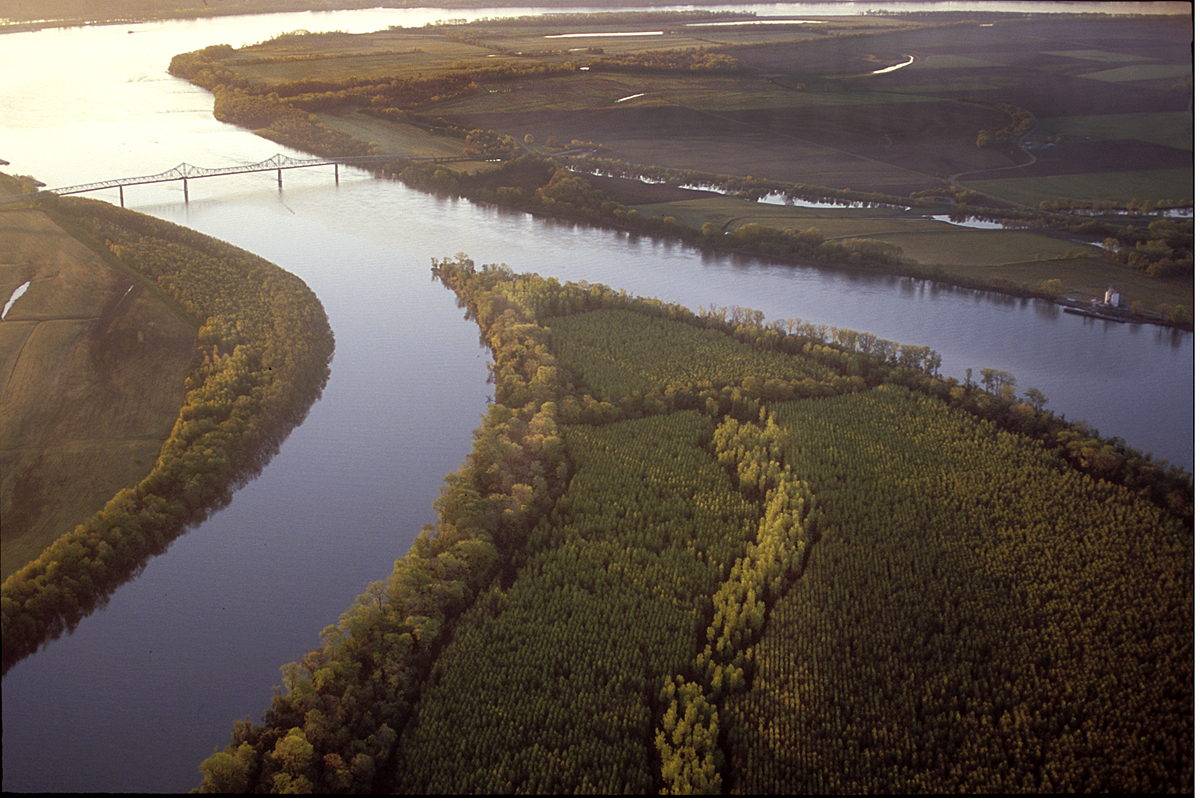
Meanwhile, the Ohio River continued to rise, cresting in many places at levels exceeding records set in the flood of 1937. Even in average conditions, the Ohio contributes more water than any other tributary. In fact, at the point of confluence at Cairo, Illinois, the Ohio is larger by volume than the Mississippi. Here is an aerial shot I took a few years ago of the confluence under normal conditions.

In late April, as both rivers steadily rose and more rain loomed in the forecast, concern grew over the levees’ ability to withstand such unprecedented pressure. The town of Cairo was evacuated and the U.S. Army Corps of Engineers considered an option last undertaken in 1937; to blow up the levee at Bird’s Point in the northern portion of Mississippi County.

The pragmatic farmers had already understood that the River would claim some crops and likely threaten some homes this year, but the level of destruction that would occur if the levee was intentionally breached far exceeded that. There was controversy and efforts to stop the action, but eventually the decision was made and 250 tons of explosives were loaded into the levee.

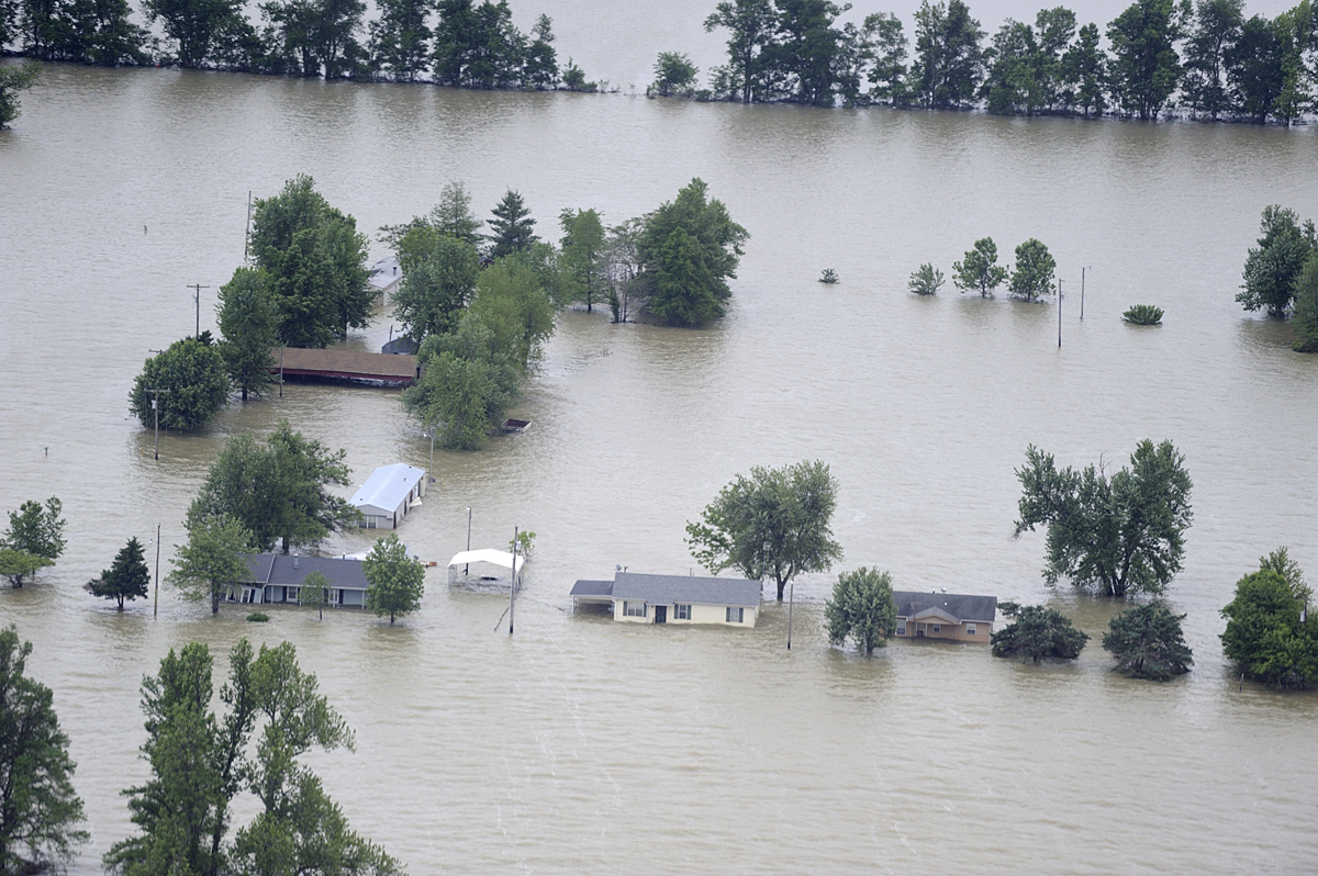
On the night of May 2nd, Sam and Silvey felt the ground pitch and roll as the horrendous force of the blast shook their home in East Prairie, some thirty miles away. Water roared through the resulting gap in the levee at 550,000 cubic feet per second and quickly flooded nearly 100 homes and 130,000 acres of crop land, including 2,000 acres farmed by Sam and Silvey. When I toured by air and by boat nearly two weeks later, I was astounded at the massive expanse of water. Here is an aerial shot at that time.

As the enormous wall of water moved downstream, levees were built up and constantly patrolled to watch for “sand boils” – evidence of water coming under the levee. The Corps decided to open the floodgates of the Bonnet Carre and Morganza spillways in Louisiana to release more water from the River. Flooding did occur on the Mississippi and as water backed up into its tributaries, but levees held and the major catastrophes that had been feared did not occur.

I visited Mississippi County again last week and found the water receding, the land reappearing and people surveying the damage. For the people of the tiny community of Pinhook, there is nothing to be done but tear down and burn what is left of their homes. I walked the streets I had traveled by boat on my previous visit. It’s a ghost town of deserted, snake-infested, destruction. The layer of silt left on the ground cracked in the heat and the air reeked with the stench of rotting vegetation, carpets and furniture.

At the Depot Café, photos spread on the counter show the deep gullies and crevasses left by the force of the water, leaving some farm fields looking like the Badlands. While some farmers are thankful to find only a layer of silt, others find piles of sand or pools as deep as 40 feet known as “blue holes.” Sam was trying to burn the thick mat of ruined wheat off the one field that had drained enough, but it was still too wet. It’s clear that most of their land will not drain in time to plant another crop this year.

The news from Louisiana is that the gates of the Bonnet Carre and Morganza spillways are now being closed as water levels drop. The gaping hole in the levee at Mississippi County, however, remains – and questions about its repair go unanswered. Those farmers who can replant are unsure if they should – the land is now vulnerable to flooding with even the slightest rise in the River. People anxious to put their lives back together are in limbo, waiting for some word.

The Corps of Engineers held a meeting in East Prairie on June 2nd, one month to the day after the levee was breached. The room was packed with residents and farmers hoping for answers to their questions, for a timeline for rebuilding the levee – for information that would let them move forward. The official answer was only, “We are here to tell you how to file a claim. No other questions will be discussed.”

When I spoke with Kevin Mainord, the Mayor of East Prairie on June 10th, he said the latest official word is that the Corps plans to “do a study of the entire lower Mississippi River.” The study will take 90 days to complete; after that they will evaluate all the work that needs to be done and assign priorities to projects.    Seriously?!!

I have read and heard accolades to the Corps for making “tough decisions in a timely manner” that prevented mass destruction all along the lower Mississippi. It is even being said that the handling of this potential crisis has restored the faith and credibility in the Corps that was lost during the Katrina fiasco. People downriver have told me they appreciate the sacrifice made by the people of Mississippi County– they feel certain their community and many others would have suffered greatly had this action not been taken.

At the time the decision was made, Major General Michael Walsh, Commander of the Mississippi Valley Division, was quoted as saying, “I’ve known many of the people who have lived and worked in the floodway for the past three years. I consider them friends, and certainly making the decision to put this in operation was a difficult decision.” Col. Vernie Reichling, Jr., commander of the Memphis District of the Army Corps was quoted as saying that while the blast was successful, it was also “historic as well as tragic.”

It seems to me that while that decision may well have been difficult, the current one should be very easy. Make it right! Tell the people of Mississippi County when the levee will be repaired, get it done and help them get on with their lives. What could be the dilemma here? If, in fact, the people of Mississippi County are the ones who were tapped to have their homes and livelihoods destroyed for the benefit of others, then it is time to thank them for their sacrifice, help them restore their lives and fix the levee as soon as possible! The potential, yet fragile, opportunity to restore the damaged reputation of the Corps is hanging in the balance here. These are resilient, self-reliant people who are accustomed to hard work. They will do all they can for themselves. It is past time to let them get started!

I found a video clip of an AP interview with Mississippi County farmer Ray Presson, standing on the edge of his flooded field. He says, without anger or resentment, “…we know that other folks up and down the River are being impacted and we know a decision had to be made…” Then, as the interviewer asks him about his emotions after putting his “blood and sweat” into the land, the farmer struggles to keep his composure, but crumples and cries on camera. The link to this is below.

If you missed it, scroll down to my post of May 29 – look at the eyes and listen to the words of George Williams, whose home of 55 years in Pinhook was destroyed.

Then, if you feel moved to do so, contact the Corps and let them know that there are many of us watching and waiting for them to do the right thing.

Here is their contact information:

U.S.Army Corps of Engineers, Mississippi Valley Division, Memphis District                       Jim Pogue, Public Affairs Chief                                                                                                Phone 901-544-4109                                                                                                                 Email  james.t.pogue@usace.army.mil

Postal address: 167 North Main Street, B202, Memphis,TN 38103-1894

http://www.youtube.com/watch?v=-HQ0WTSiXHM  interview with farmer

Thank you for caring!   Gayle

Filed Under: 2011 Mississippi River Flooding, MO - Bootheel, MO - East Prairie, MO - Pinhook Tagged With: Mississippi County Missouri Flooding, Mississippi River Flooding 2011, U.S. Army Corps of Engineers

Stories of the Mississippi River Flood of 2011

May 29, 2011 by Gayle Harper 5 Comments

After my recent trip to the flooded area of southeast Missouri known as the bootheel, I came home to meet a previous commitment for the days since then. I am just now resurfacing to catch up with the news and see the effects of flooding on the lower Mississippi. Another trip is in the planning stage – but, for now, I want to share some of the stories of the people of the flooded land of the Missouri bootheel.

“Mr. George – I’ve brought you company!” announces my friend, Silvey, as we walk into the school bus barn. “Well, get on in here!” a voice calls from beneath a school bus. A tall, smiling man slides out, wipes the grease from his hands and welcomes me with a deep throaty chuckle. Probably everyone in East Prairie, Missouri, knows George Williams – he has been driving the local school bus since 1962. His warm handshake and direct gaze give me an immediate image of several generations of students holding both respect and affection for this gentle, strong man.

We sit on metal folding chairs in a corner of the bus barn and Silvey tells him about my upcoming book and my interest in hearing about his life in Pinhook, Missouri. His smile fades, he shakes his head sadly and says, “Tell you the truth, Miss Silvey, I’m real glad my wife ain’t alive to see what happened to our home. I believe it’d be too much for her.” He is quiet a moment as he looks down and sighs deeply. I feel his weariness as he says again, “I sure ‘nuf am glad she ain’t here to see her house like this.”

“Mr. George” as he is known, has lived in Pinhook for 58 years. There have been three or four lesser floods over those years, but nothing like this one. This time the water went up to his roof and the house will have to be torn down. He won’t go back, he says, “There ain’t nothin’ there to go back to.”

I’m piecing together the history of Pinhook, Missouri, and by the time it goes into the book, I’ll have a more complete picture. So far, I am told the community was created as a result of the sharecropper’s revolt of 1939. In recognition of and reparation for the bad treatment received, land was made available to the Christian Liberty Association. African Americans, who were otherwise prohibited from owning land at that time, could obtain 40 acre plots through that organization. Farms and homesteads were created and the community of Pinhook was born.

Pinhook thrived for a time – during the 1950s and 60s, it was home to as many as 250 people. In the years since then, however, things got tougher and much of the land was sold off as families struggled to support themselves. It’s always been a tight-knit community where people take care of each other. “Most everybody’s family in some way or ‘nother,” he says, smiling again.

“We raised our own nine kids there,” he tells me, “plus ten others that needed a home.” They all had to move away, though, in order to find jobs. When the floodwaters came this spring, Pinhook had dwindled to just 18 families. Now those families are all staying with relatives and friends, hoping to figure out what to do “before they wear out their welcome.” No one he knows plans to go back. “Pinhook,” he says, “is history.”

I know as I leave Mr. George that I will likely see his flooded house before he will. I am scheduled to tour the area by air and by boat later today. My words of empathy and comfort seem to me inadequate for his loss, but his warm smile is back as we say goodbye and I feel his resilience and goodness.

My pilot knows which house belongs to Mr. George and points it out, half-submerged and surrounded by a vast sea of murky water. Even from here, I can tell it sits at the end of a street of well-tended homes.

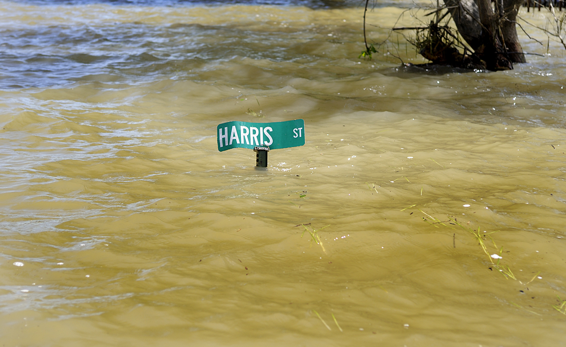
The closer and more heart-wrenching view of Pinhook, however, is from the boat. A street sign barely extends above the water.


Houses are torn apart by the powerful current and waves created by the wind. I know that under the carport Mr. George’s “old but good” 1979 Dodge Diplomat lies submerged; he couldn’t drive it out because the water came up quicker than expected.


Water rushes through Mr. George’s house and an entire section of wall bobs loosely with the waves. Vertical blinds wobble with the current rushing through the shattered picture window. All the drapes and blinds are drawn shut and I imagine the final moments of closing the house up, locking the door and hoping against hope. The silence feels hollow and dead, as if the water has washed away even the echoes of those who lived here. There is not even a bird call – nothing but the putter of our boat motor as we ride the choppy water a dozen feet above the street.

Pinhook Day would have been this weekend. Nearly everyone who ever lived at Pinhook came home over Memorial Day weekend. Every house would have been bursting with people gathered for noisy reunion picnics filled with laughter, conversation, music and good food. To all of you who would have been there today, my heart goes out to you.

The resilience and goodness I saw in Mr. George Williams is obvious in his family. A few of his children and grandchildren came together to create a song, dedicated to all people affected by the flood of 2011. In it they sing of their lost childhood home, but also of the home they hold in their hearts, wherever they are. It’s a celebration, they say, of the love they grew up with that can never be washed away. Here is a link to their beautiful tribute www.youtube.com/watch?v=YjRj1ULvE7k

 In love and peace,

 Gayle


Filed Under: 2011 Mississippi River Flooding, MO - East Prairie, MO - Pinhook Tagged With: Bootheel of Missouri, East Prairie Missouri, Flooding 2011, Mississippi River Flood of 2011, Pinhook Missouri

Dust, Southern Charm and Something Ancient

October 24, 2010 by Gayle Harper 5 Comments

I’ve visited this area of southeast Missouri known as “The Bootheel” before and made some friends I was happy to see again. Claudia and Randy Arington invited me to stay with them in the country outside of Charleston, MO. When they told me the hill south of Cape Girardeau was the last hill on this side of the river, they weren’t kidding. The land now is flat and low as far as the eye can see.  Before the Little River Drainage Project began in 1907, this was a vast swampland, thickly forested with Tupelo and Cypress trees (like these I shot across the river at Horseshoe Lake) and populated mostly by snakes, frogs, ducks, herons, egrets and a rich assortment of other wildlife. By 1927, the forests were cleared and the swamps almost completely gone, drained by nearly 1,000 miles of ditches and over 300 miles of levees.  What remains is some of the richest farmland in the country. Mile after mile of cultivated and irrigated land now produces soybeans, wheat and corn.

Farming is still a risky business, dependent on factors beyond human control. Remember all that rain I was in up north? Most farmers here say they haven’t seen a good rain since June. A few weeks ago the Mississippi was swollen with that northern rain making its way to the Gulf, but the land alongside is parched. I expected to see vibrant fall colors, but have found crackly, brown leaves instead. Its harvest time and that means long hours in combines in the dusty fields, sometimes well after dark. Often it’s hard to even see the tractor and equipment through the huge cloud of dust it raises. By afternoon, the air is hazy with it. It’s hard to imagine this as a vast swamp less than a century ago.

Missouri’s neighbor across the river now is Kentucky and there are no bridges between the two states. If you want to drive across, the only way is the Dorena-Hickman ferry, which is far more fun anyway!  Claudia and Randy had arranged for Tammi Hutcheson of the Mississippi County Port Authority to meet us at the ferry for its first run of the morning. The river was still misty as we drove aboard and the morning light soft and low.

Captain Ed Floyd invited us to visit him up top and share his lofty view.  The barge, which can hold a dozen cars, is attached to the tugboat by an arm that pivots.  When it reaches the opposite shore, the Captain swings the boat around to face the opposite direction while the deckhand directs traffic off and on again. 

It’s an efficient and valuable service for locals and for travelers, an inexpensive way to get out on the Mississippi.  The confluence with the Ohio River just north of here more than doubled the amount of water the Mississippi River is carrying and crossing it in this way allows an up-close experience of that immensity.  

Charleston is charming at any time, but it’s downright magical in spring. My previous visit here was for the Dogwood-Azalea Festival which takes place every April when the town is a fairyland of white and pink blooms.  In the evening when the sidewalks are filled with people strolling and lined with paper-bag luminaries, it’s like being painted into a Norman Rockwell scene. Click here if you’d like to see some of my shots of Charleston in bloom.

Charleston clearly identifies itself as a Southern town. People are addressed as Miss Claudia and Miss Molly. Most single-syllable words now have three and the standard refreshment is sweet tea (pronounced as one word).  The social calendar also has a Southern touch, including the meeting of the Southeast District of the Federated Garden Clubs of Missouri, which the Charleston ladies in decorated straw hats, hosted. 

There was a flower show and competition and a spoof of Wizard of Oz for entertainment.

The audience swayed with the wind when instructed, laughed heartily and gave a standing ovation at the end.

For the sunset, I met my other friend in the area, Silvey Barker, who took me to a very special place. The Towosahgy State Historic Site is a little-known prehistoric Indian Village near East Prairie, MO.  Between A.D. 1000 and 1400, several thousand people of the mound building Mississippian Culture lived here. What remains today are a large Temple Mound and several smaller mounds. There is really no vantage point to photograph it effectively, but in a way that only adds to its mystique. 

Chris Crabtree, the DNR guide at the site, gave us a tour and told us what is known about the people who lived here. As the sun started to set and the almost-full moon rose, Chris left but Silvey and I were allowed to stay as long as we liked. Silvey has been here many times; she and her husband farm the adjacent land. She said, “I’m going to walk back to the car. I think you should have some time here alone.”

I sat on the broad, flat top of the Temple Mound and watched the gathering dusk, then closed my eyes and meditated. There was a very deep Stillness and a sensation of being anchored to the earth. I cannot say whether the clinking sound I heard was someone on a distant farm, a bird or insect I am unfamiliar with or the ankle bells of some ancient dancers. I cannot offer any explanation for the wall of cold air I walked into and out of again as I left. I can only say I am thankful that this ancient site is now protected and preserved, to honor those who lived here and to allow the rest of us to experience it, each in our own way.

Peace,     Gayle

Filed Under: MO - Charleston, MO - East Prairie, The Bootheel Tagged With: Charleston Dogwood Azalea Festival, Cypress Trees, Dorena-Hickman Ferry, Towosahgy Historic Site

Copyright © 2025 Gayle Harper