This post will be longer than usual. I hope you will bear with me – there are some good people who could use your help. But first, some background.
Mississippi County, Missouri, is a place where many people’s roots go very deep. Unlike some agricultural communities where family farms have succumbed to wealthy corporations, many of the farmers here are working land that has been in their family for three or four generations. My friends Sam and Silvey Barker grew up in this county on land that was first cleared by their respective grandparents, long before the current system of levees and spillways existed.
As I sit with them in the Depot Café in the heart of the small town of East Prairie, it seems everyone knows everyone. It gets noisy – people shove tables together to join groups and move from table to table greeting one another. Someone returns from a nearby town with his pickup loaded with flats of fresh-picked strawberries. They looked good, so he brought plenty to share. A friend of Silvey’s granddaughter runs over to give a hug and someone comes by with a report of an ailing neighbor.
The county’s namesake and its eastern border is the Mississippi River. It is part of the rhythm of life here that the River rises and falls. Farming is always a gamble – nature is capricious and uncontrollable. Some years, all the right conditions come together to produce a good crop and the market offers a good price. In others, there may be extreme heat or drought or an enormous migrating flock of snow geese may stop to feed on fields of tender, young wheat, or there may be a flood. “People feel they are a part of the natural world here,” Silvey tells me, “and for the most part, we flow with what happens and just keep going.”
The spring of 2011 started out looking fortuitous – the rains came at the right time and in April the fields were golden with wheat just starting to “head out.” Across the upper Midwest, however, deep snow pack left by record-setting blizzards was beginning to melt, swelling creeks and rivers that flow into the Mississippi. At the same time, torrential rainstorms pelted much of the River’s enormous drainage basin, which includes 41% of the land mass of the continental U.S. Communities along the upper Mississippi watched their levees anxiously and in many cases, added height with layers of sandbags. As the growing bulge of water crested and passed by without overtopping the levees, people along the upper River breathed a sigh of relief.
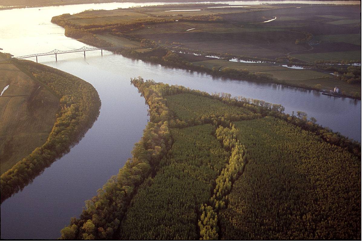
Meanwhile, the Ohio River continued to rise, cresting in many places at levels exceeding records set in the flood of 1937. Even in average conditions, the Ohio contributes more water than any other tributary. In fact, at the point of confluence at Cairo, Illinois, the Ohio is larger by volume than the Mississippi. Here is an aerial shot I took a few years ago of the confluence under normal conditions.
 In late April, as both rivers steadily rose and more rain loomed in the forecast, concern grew over the levees’ ability to withstand such unprecedented pressure. The town of Cairo was evacuated and the U.S. Army Corps of Engineers considered an option last undertaken in 1937; to blow up the levee at Bird’s Point in the northern portion of Mississippi County.
The pragmatic farmers had already understood that the River would claim some crops and likely threaten some homes this year, but the level of destruction that would occur if the levee was intentionally breached far exceeded that. There was controversy and efforts to stop the action, but eventually the decision was made and 250 tons of explosives were loaded into the levee.
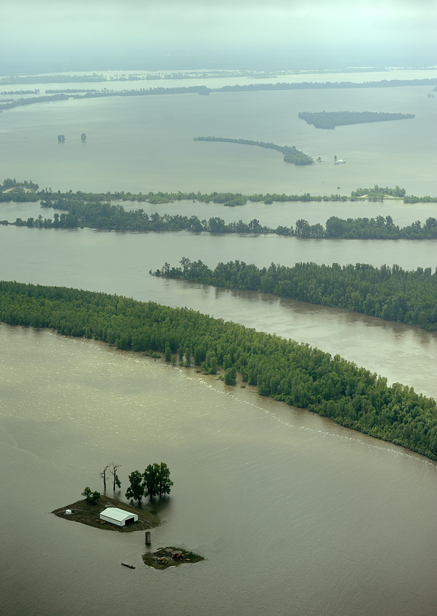
On the night of May 2nd, Sam and Silvey felt the ground pitch and roll as the horrendous force of the blast shook their home in East Prairie, some thirty miles away. Water roared through the resulting gap in the levee at 550,000 cubic feet per second and quickly flooded nearly 100 homes and 130,000 acres of crop land, including 2,000 acres farmed by Sam and Silvey. When I toured by air and by boat nearly two weeks later, I was astounded at the massive expanse of water. Here is an aerial shot at that time.
As the enormous wall of water moved downstream, levees were built up and constantly patrolled to watch for “sand boils” – evidence of water coming under the levee. The Corps decided to open the floodgates of the Bonnet Carre and Morganza spillways in Louisiana to release more water from the River. Flooding did occur on the Mississippi and as water backed up into its tributaries, but levees held and the major catastrophes that had been feared did not occur.
I visited Mississippi County again last week and found the water receding, the land reappearing and people surveying the damage. For the people of the tiny community of Pinhook, there is nothing to be done but tear down and burn what is left of their homes. I walked the streets I had traveled by boat on my previous visit. It’s a ghost town of deserted, snake-infested, destruction. The layer of silt left on the ground cracked in the heat and the air reeked with the stench of rotting vegetation, carpets and furniture.
At the Depot Café, photos spread on the counter show the deep gullies and crevasses left by the force of the water, leaving some farm fields looking like the Badlands. While some farmers are thankful to find only a layer of silt, others find piles of sand or pools as deep as 40 feet known as “blue holes.” Sam was trying to burn the thick mat of ruined wheat off the one field that had drained enough, but it was still too wet. It’s clear that most of their land will not drain in time to plant another crop this year.
The news from Louisiana is that the gates of the Bonnet Carre and Morganza spillways are now being closed as water levels drop. The gaping hole in the levee at Mississippi County, however, remains – and questions about its repair go unanswered. Those farmers who can replant are unsure if they should – the land is now vulnerable to flooding with even the slightest rise in the River. People anxious to put their lives back together are in limbo, waiting for some word.
The Corps of Engineers held a meeting in East Prairie on June 2nd, one month to the day after the levee was breached. The room was packed with residents and farmers hoping for answers to their questions, for a timeline for rebuilding the levee – for information that would let them move forward. The official answer was only, “We are here to tell you how to file a claim. No other questions will be discussed.”
When I spoke with Kevin Mainord, the Mayor of East Prairie on June 10th, he said the latest official word is that the Corps plans to “do a study of the entire lower Mississippi River.” The study will take 90 days to complete; after that they will evaluate all the work that needs to be done and assign priorities to projects. Seriously?!!
I have read and heard accolades to the Corps for making “tough decisions in a timely manner” that prevented mass destruction all along the lower Mississippi. It is even being said that the handling of this potential crisis has restored the faith and credibility in the Corps that was lost during the Katrina fiasco. People downriver have told me they appreciate the sacrifice made by the people of Mississippi County– they feel certain their community and many others would have suffered greatly had this action not been taken.
At the time the decision was made, Major General Michael Walsh, Commander of the Mississippi Valley Division, was quoted as saying, “I’ve known many of the people who have lived and worked in the floodway for the past three years. I consider them friends, and certainly making the decision to put this in operation was a difficult decision.” Col. Vernie Reichling, Jr., commander of the Memphis District of the Army Corps was quoted as saying that while the blast was successful, it was also “historic as well as tragic.”
It seems to me that while that decision may well have been difficult, the current one should be very easy. Make it right! Tell the people of Mississippi County when the levee will be repaired, get it done and help them get on with their lives. What could be the dilemma here? If, in fact, the people of Mississippi County are the ones who were tapped to have their homes and livelihoods destroyed for the benefit of others, then it is time to thank them for their sacrifice, help them restore their lives and fix the levee as soon as possible! The potential, yet fragile, opportunity to restore the damaged reputation of the Corps is hanging in the balance here. These are resilient, self-reliant people who are accustomed to hard work. They will do all they can for themselves. It is past time to let them get started!
I found a video clip of an AP interview with Mississippi County farmer Ray Presson, standing on the edge of his flooded field. He says, without anger or resentment, “…we know that other folks up and down the River are being impacted and we know a decision had to be made…” Then, as the interviewer asks him about his emotions after putting his “blood and sweat” into the land, the farmer struggles to keep his composure, but crumples and cries on camera. The link to this is below.
If you missed it, scroll down to my post of May 29 – look at the eyes and listen to the words of George Williams, whose home of 55 years in Pinhook was destroyed.
Then, if you feel moved to do so, contact the Corps and let them know that there are many of us watching and waiting for them to do the right thing.
Here is their contact information:
U.S.Army Corps of Engineers, Mississippi Valley Division, Memphis District Jim Pogue, Public Affairs Chief Phone 901-544-4109 Email james.t.pogue@usace.army.mil
Postal address: 167 North Main Street, B202, Memphis,TN 38103-1894
http://www.youtube.com/watch?v=-HQ0WTSiXHM interview with farmer
Thank you for caring! Gayle